Showing posts with label River Ouse. Show all posts

Friday, 25 September 2009

Follow The Foss - 1 - Blue Bridge to Castle Mills Bridge

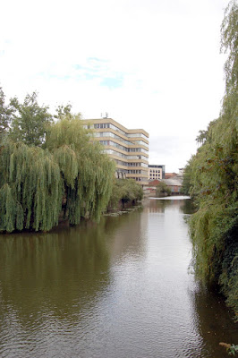
Over the coming days I plan to meander along York's second river the River Foss.Journeying on foot I plan to take a photograph at approximately every 100 paces to show the changing scenery and character of the river. In some places where no path is available it will be necessary to make a small diversion around obstacles and rejoin the river as the earliest opportunity.  Starting from the confluence of the Foss and the larger Ouse the route will proceed upstream through the city centre and out of the city towards Huntington. In general the photographs will be looking upstream along the river in the direction of travel except when following a diversion around an obstacle or when an interesting downstream opportunity presents itself..


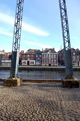
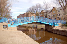
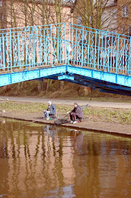
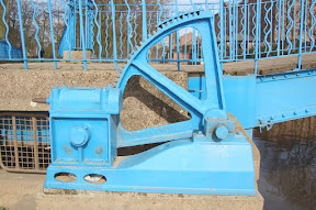
Blue Bridge a hand cranked lifting bridge.


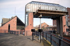
Foss barrier flood prevention scheme


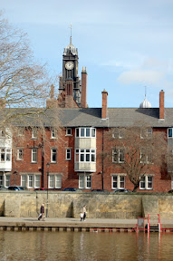
Approaching Foss Basin and Castle Mills lock with Castle Museum in background


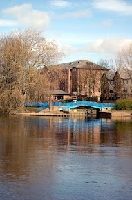
Foss basin with Castle Museum in background, the locks can be seen to the right of the picture.


 Castle Mills lock


Castle Mills bridge is the first diversion away from the river, turning left at the top of the steps beside the lock follow the footpath to the end of the railings and then cross the road at the earliest opportunity, traffic permitting. Continue away from the river aournd the Law Courts and Castle Museum building.


View Follow The Foss in a larger map

To be continued

Saturday, 7 February 2009

Baile Hill entrance to walls


Baile Hill is the earth mound behind the tower and dates back to 1068 when it was constructed as a second fortification after the Norman Conquest of 1066. The defence was a typical Motte and Bailey construction like the site where Clifford's Tower now stands on the other side of the River Ouse. Nobody knows which mound was constructed first although it is generally thought that the one on the eastern side of the river was built first.

Tuesday, 6 January 2009

Lendal Tower and Bridge


My eldest son was home over the holiday and can be seen here with his back to the camera looking towards Lendal Bridge and Lendal Tower.

Monday, 5 January 2009

York City Rowing Club


I think it is admirable the way these youngsters get out on a cold morning take most of their clothes off and then row up and down the river in boats so flimsy that one man can lift them out of the water whilst being shouted at not to scrape the bottom of the boat as it is already very thin. Just by Lendal Bridge the rowing club is situated next to the river ouse where you often see rowers pulling up and down the river.

Sunday, 30 November 2008

View from Queenstaith to Kingstaith


From Queenstaith over the River Ouse you can see the buildings along Queenstaith. In the far left is the King's Arms pub famous for being flooded when the river rises. The building was originally built as a customs house for when ships travelled up the Ouse to York. It was known as the Ouse Bridge Inn before succumbing to being rebranded as the King's ArmsOn the far right of the picture is the Lowther Hotel, another public house. Cumberland Street runs uphill next to the Lowther.

Sunday, 9 November 2008

Pedestrian and cycle tunnel by Railway Museum


This is a tunnel that a lot of visitors to the railway museum will use on their way to the National Railway Museum. It passes under the York to Scarborough railway line just before the line crosses the River Ouse over Scarborough Bridge.

Friday, 18 July 2008

King's Arms, Ouse Bridge Inn, King's Arms


The King's Arms is a former 17th century customs house which became a pub in 1783. It was originally known as the King's Arms possibly named after the customs house crest. In the 19th century it had a change of name to the Ouse Bridge Inn. Did they have marketing people back then doing "relaunches"! In 1974 the name was changed back to the King's Arms to commemorate Richard III depicted on the present day sign. This change was at a time when he was being sold as not being as bad as he had been portrayed, possibly a case of the victor writing history to suit their own needs. The one remaining link to the intermediate naming of the pub can be seen as you walk up King's Street where the etched windows still have the name Ouse Bridge Inn.

Thursday, 17 July 2008

Lowther Hotel


The bright colours of the lower section that has been repainted make the Lowther seem less forbidding than the previos black waterproofing of the lower level. I am sure whether it will be practical though, as it will probably need regular repainting after each flooding.

Wednesday, 16 July 2008

Woodsmill


View across the River Ouse from Kingstaith towards Woodsmill building. The river is at a normal level. During flood times the bollards can be under water.

Thursday, 5 June 2008

Marygate corner tower

From Exhibition Square along Bootham the city wall runs directly behind a pub and several private properties emerging on the corner of Marygate with a round tower where it turns left and follows the line of Marygate past St. Olave's church down to the River Ouse.

Tuesday, 22 April 2008

Micklegate Bar

For those travelling into York by road from the west they are welcomed to the city centre by the sight of Micklegate Bar, the western gateway to the city running past All Saints Church towards the River Ouse. Most visitors though will either turn left or right at this point in search of somewhere to park their car. Be warned though, car parking in York is expensive and it is advisable to use one of the many Park and Ride facilities around the perimeter of the city.

Wednesday, 9 April 2008

Clock Tower on Magistartes Court

This is a view across the River Ouse from Skeldergate where the clock tower of the magistrates court looms over the surrounding buildings. Prior to it's use as a magistrates court it was the York Technical College which is now housed on the edge of York on Tadcaster Road at Askham Bar.

Tuesday, 8 April 2008

Blue Bridge fromTerry Avenue

This is the view across the River Ouse towards Blue Bridge where the River Foss joins the River Ouse. The River water level is high though not in flood. When there are high levels of rainfall in the Yorkshire dales the water becomes heavy with peat, hence the brown colouration of the water.

Tuesday, 18 March 2008

Foss Barrier and Pumping Station

The barrier is part of the flood defences created after the severe floods of 1982. The River Ouse is fed by the Rivers Ure, Swale and Nidd draining the Yorkshire Dales and often used to cause a back flow along the low lying River Foss flooding areas of York like Foss Islands and Huntington Road bordering the river. To prevent the back flow along the Foss the barrier was constructed and is lowered when the level of water at the barrier reaches 7.8 metres. The weight of the barrier is sixteen and a half tonnes. To prevent the water in the River Foss Backing up on itself the water is pumped from the Foss into the River Ouse. During the severe floods of Autumn 2000 the barrier was in place for 18 days and the pumps were used continuously for ten days at a power consumption cost of £20,000.

Monday, 17 March 2008

Blue Bridge

Built in 1895, Blue Bridge replaced the previous bridge built in 1738. The bridge stands at the mouth of the River Foss where it joins the River Ouse. Note two fishermen sitting at the side of the Foss. The bridge is located just beyond the Foss barrier and pumping station.

There is gear for lifting the bridge but I don't know if it has been used in the recent past. The paint on the teeth looks far too pristine to me.

Sunday, 16 March 2008

Skeldergate Bridge

A spring day and the River Ouse is a peaty brown and reasonably full without bursting the banks. You can see water marks on the bridge towers from previous high levels. The River Ouse is the confluence of several rivers including the The Swale, The Ure, The Nidd and the much smaller Kyle. Just below Skeldergate Bridge it is also joined by The Foss.

The bridge standing on the site of a former ferry was designed by Thomas Page, who also designed Westminster bridge in London building took place in the 1880s and included a mechanism for the bridge to be raised for ships. It was last raised in 1975.

Tuesday, 26 February 2008

Ornamentation - Lendal Bridge

Lendal bridge over the River Ouse in York is loaded with symbols, starting with five lions en passant representing the city, the entwined V and A representing Queen Victoria and Prince Albert, VR for Victoria Regina with the white rose of Yorkshire above it and the crossed keys of the clergy.

Sunday, 7 October 2007

River Foss behind Piccadily

Behind the rather run down area Piccadily, that includes the second most ugly building of York, Ryedale House. The lines of decay and ugliness are softened by the willow trees along the bank as the river runs along the final stretch before meeting the River Ouse at Blue Bridge.