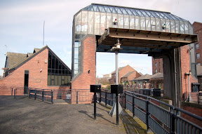
The barrier is part of the flood defences created after the severe floods of 1982. The River Ouse is fed by the Rivers Ure, Swale and Nidd draining the Yorkshire Dales and often used to cause a back flow along the low lying River Foss flooding areas of York like Foss Islands and Huntington Road bordering the river. To prevent the back flow along the Foss the barrier was constructed and is lowered when the level of water at the barrier reaches 7.8 metres. The weight of the barrier is sixteen and a half tonnes. To prevent the water in the River Foss Backing up on itself the water is pumped from the Foss into the River Ouse. During the severe floods of Autumn 2000 the barrier was in place for 18 days and the pumps were used continuously for ten days at a power consumption cost of £20,000.
Tuesday, 18 March 2008
Foss Barrier and Pumping Station
Posted by
JollyGreenP
at
08:45
5
comments
Labels: flood, Foss Barrier, River Foss, River Nidd, River Ouse
Sunday, 16 March 2008
Skeldergate Bridge
A spring day and the River Ouse is a peaty brown and reasonably full without bursting the banks. You can see water marks on the bridge towers from previous high levels. The River Ouse is the confluence of several rivers including the The Swale, The Ure, The Nidd and the much smaller Kyle. Just below Skeldergate Bridge it is also joined by The Foss.
The bridge standing on the site of a former ferry was designed by Thomas Page, who also designed Westminster bridge in London building took place in the 1880s and included a mechanism for the bridge to be raised for ships. It was last raised in 1975.
Posted by
JollyGreenP
at
08:45
0
comments
Labels: River Foss, River Kyle, River Nidd, River Ouse, Skeldergate Bridge