Showing posts with label Fossbank. Show all posts

Tuesday, 5 July 2016


Although the gas works in York ceased operating in York many years ago you can still see traces like the pipeline across the River Foss that carried gas from the gas works into the city. Nowadays natural gas is piped through these pipes from the pump control room in Layerthorpe. Below is a pile drill on the site of the old gas works drilling deep holes to put in foundations for buildings to be erected on the site (probably another hotel). Just beyond the drill there will be a new road linking Malton Road to James Street giving the chance to avoid the circuitous route round Foss Bank onto Foss Islands Road to Lawrence Street and Hull Road.


Tuesday, 29 September 2009

Follow the Foss - 5 - Along Fossbank to Heworth Green

Gone are the interesting parts like the building reclamation yard, Ossie's scrap yard, the gas and coking works with the bridge carrying a large gas pipe over the river and road. You have to look hard for some of the remains and what has replaced it is standard pastry cutter design industrial, commercial and high density housing buildings(slums of the future? only time will tell!).


Where the cars in the foreground are parked is where the reclamation yard used to stand. Ornate and interesting chimney spots were stacked around the yard. Rainfall has been a bit low this year and weed growth has become prominent in this section of the river as water levels have fallen.

Hidden  in the trees you can just make out the blue and whitesignboard of the automotive spares building of Partco. In the background is the high density housing and office buildings that have been built on the gas works site.


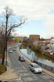
This picture is notable for the lack of the gas storage tank which normally dominates thesky line, presumably deflated as there is less gas demand during the summer months, or has that reached an end point and being decommisioned?

All that remains of the viaduct that carried a substantial gas main over the river and road are these two green foundation footings.  Rubbish in the water this year seems to be a particular problem. Maybe it is something to do with the low levels of water flowing in the river so it doesn't get washed out into the Ouse and become someone elses problem, or is it just a symptom of untidy city dwellers and a council strapped for cash?


Approaching Heworth green there is a small concrete bridge in front of the main Heworth Green road bridge another of the few remaining bits of the old gas works site.

Fossbank joins Heworth Green, Huntington Road and Monkgate at the Monk Roundabout. Cross to Huntington Road via Heworth Green.


View Follow The Foss in a larger map

Monday, 28 September 2009

Follow The Foss - 4 - Foss view to Foss Islands Bridge

This section of the Foss is where there is no section of city wall. The River Foss formed a large swampy area around here which was eventually cut into a drainage channel and the swampy area that is now Hungate was drained. Hungate is undergoing redevelopment and has been thoroughly dug over by the archaeologists who have turned up finds from Roman times through Viking up to the early 19th century. The first stage of the redevlopment is nearing completion and the buildings along Foss View are starting to be occupied.


Although the City Council have a rubbish collecting boat you can just see it in the distance beyond the covered section of walkway I have never seen it being used. The current state of rubbish in the river makes me wonder if it has been used at all this year.

Just out of the covered walkway gives a closer glimpse of the moored rubbish collection boat and the chimney from the former power station that used to generate electricity for the city now standing next to Morrisons. The power station building that housed the generators stood where Halfords and Staples now stands.


The cooling tower for the power station used to stand on the far side of the river behind the trees you can see in the above picture. Access to the cooling tower was via the little bridge painted blue.

Continuing upstream on the left behind the trees you can just about see the edge of the DEFRA site (or whatever they are calling themselves these days, they used to be MAFF) which stands on the former site of engineering firm Adam's Hydraulics. Straight ahead you can see one of the bridge structures of the Foss Islands junction. This junction used to be a learner's nightmare with two hump backed bridges and multiple junctions to negotiate.


Behind the bridge you can see the point where the city walls break at Layerthorpe Postern and the marshlands of Foss Islands provided the defence line for the city. On foot you now need to follow a complicated route to get yourself onto Fossbank, see map below. Turn left onto the bridge in the above picture cross towards Layerthorpe Postern but at the island in between turn right to take you past the lighting arrangement in the following picture and then left where you will be against the flow of motor traffic onto Fossbank.


View Follow The Foss in a larger map

Tuesday, 1 July 2008

City Wall Feature Markers


As you walk around the city walls of York you will come across markers on the floor highlighting points of interest. These two markers can be found on the stretch of wall between Foss Islands (Layerthorpe Bridge) and Monk Bar. They mark the ice house which is next to Monk Bar and the Jewish Burial ground that used to stand on the site of the Fossbank car park.

Thursday, 17 April 2008

Sainsbury's Fossbank

Call me old fashioned but I just don't understand the architecture of this building. Was the intention that another story should go on top? Did they run out of money to build the second story? Or is it just a case of that is the design? Answer's on a post card please!

Wednesday, 16 April 2008

Fossbank

Fossbank is the location of one of the Sainsbury supermarkets in York and the car park looks out over the River Foss towards the gasometer and former gas works at Layerthorpe.